Hokkaido is the second largest island in Japan. The Tsugaru Strait separates it from the great island of Honshu although they remain united through the Seikan tunnel. The largest city of Hokkaido is Sapporo, its capital.
Hokkaido has several seasons for tourism: winter to enjoy its ski slopes, July to see the fields booming, or as in my case, early May to see the cherry blossom. Hokkaido is not the most popular or desired place to see the Sakura trees but I must admit it was worth it. There were hardly people, low season, pleasant temperature, sunny days, although sometimes the air rose with small rains. But it has been one of my best trips ever made alone along with my camera.
The time needed depends on how you are going to move around and if you are only going to see cities or not. In my case, were 8 days.
The chosen route was: 3 nights in Sapporo, 2 nights in Hakodate, 1 night in Sapporo (transit), 3 nights in Asahikawa. Maybe if you move by car you don’t need so much time, so it depends a lot on transportation
What places to see in Hokkaido no matter is Sakura season or not?
- Sapporo
- Maruyama Park
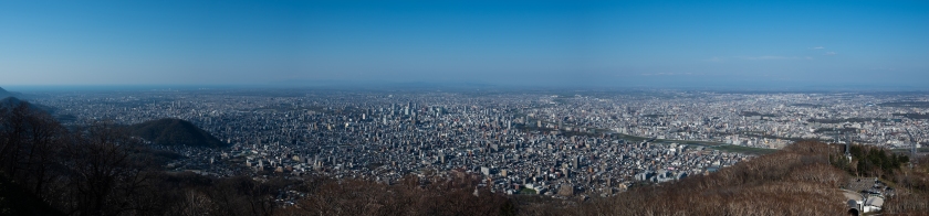
- Mount Moiwa
- Nakajima Park
- Sapporo TV Tower
- Otaru
- Otaru Canal
- Fukamizaka
- Ryugu Shrine
- Temiya Park 手宮公園
- Hakodate
- Bay Area
- Motomachi Park
- Catholic Church Hakodate Motomachi
- Hakodate Orthodox Church
- Mount Hakodate
- Cape Tachimach
- Goryōkaku Park
- Asahikawa
- Tokiwa Park
- Asahikawa Forest Park
- Furano & Biei
Sapporo
1. Walk at Maruyama Park


Location: https://goo.gl/maps/26Qk6gZSdjNipf5X6
Perfect place to walk and see its Shrines and highly recommended if you want to see Sakura trees! Great to spend a couple of hours and relax. To get here take the metro line Tozai to Maruyama Koen Station, exit 1
2. Go up to Mount Moiwa
Location: https://goo.gl/maps/nbZex9mefAA8wpsw6
If you visited Maruyama Park before, this small mountain is about 40 minutes walking distance or also accessible by tram.
The views from the top are incredible, you can see almost all Sapporo city.
To get here, you must take the tram to Ropeway Iriguchi and follow directions to the cable car to buy the ticket to the cable car. The cable car leads to two different destinations and the price of the ticket varies depending on each one. The first stop is Moiwa Chufuku Station and the second is Moiwa Sancho Station. Sancho Station can also be accessed by walking through a small path at the top of Chufuku Station.
During this season the queue to get the ticket was quite short!
3. Walk in Nakajima Park


Location: https://goo.gl/maps/ECrxgfTwKBwiMm7EA
Another park located in the city center for a walk or boat ride.
You can get to this park by metro Namboku line to Nakajimakoen Station or get off at Susukino Station and walk to enjoy its traditional streets.
Near this park there are hundreds of restaurants. You cannot miss to try the Miso Ramen, typical dish of Sapporo!
So if you are still around and it is time for lunch, this local restaurant is really great and is about 10 minutes walking distance from the park up to the North
Recommendation: https://goo.gl/maps/c7b2zPnD9S6DBuJA8
4. Enjoy the views from the top of Sapporo TV Tower


Location: https://goo.gl/maps/33XnwJCAuJWsAVie8
Famous TV tower built in the 1950s, with an observation deck offering panoramic views of the city.
To get here you can by subway Namboku, Toho or Tozai lines to Ōdōri Station.
Opens every day from 9am to 10pm
Otaru
If you are staying in Sapporo, you can get to Otaru by train JR Hakodate Line departing from Sapporo Station. Cost: ¥740
1. Walk along Otaru Canal


Location: https://goo.gl/maps/H4J48gdA7JmrnZKd8
Perfect for a walk along its canal or boat ride. This canal runs through the entire town until almost reaching the Temiya park surrounded by bars, restaurants and shops.
From the Otaru Station you can reach here by walking
If you are looking for places to eat, there are some alleys near the canal that are quite popular! It is worth taking a look at the risk of queuing to get seated!
Location: https://goo.gl/maps/PYfdcKJMN8tXYPJC8

2. Visit the popular street of Fukamizaka


Location: https://goo.gl/maps/nEkrmvLV1RYYBh6u9
This street is quite popular for the Love Letter movie. Highly recommended to pass through here in winter with the snowy streets. The rest of the year you don’t see anything in particular
3. Visit Ryugu Shrine

Location: https://goo.gl/maps/wJBqi5eSdxM5MpP66
This Shrine is found only few meters away from Fukamizaka Street
4. Visit the Temiya Park 手宮公園


Location: https://goo.gl/maps/6tDD2PD2uH9vxB877
Personally, one of the pearls of Otaru and not so popular. The Sakura are incredibly beautiful in this park. To get here you have to walk along the canal and climb a hill. It takes roughly 30 minutes but it is totally worth it. From the top of the park there are views of Otaru and is full of picnic areas. Ideal place to come with family or couple or even for photography!
Hakodate
To get to Hakodate from Sapporo, you can take the JR Train from Sapporo Station or take a bus. The journey takes about 4-5 hours and reaches to Hakodate Station. The bus Station is right in front of the Train Station. You can get the train tickets directly from the vending machines or in case want to travel by bus you can book a bus ticket through this website. The buses are more affordable, provides big and comfortable seats and are individual! The seats are all separated from each other.
Once you arrive in Hakodate, is recommended to buy a ticket for 1 or 2 days for the tram. This would save us time and money when using this service, since the tram is quite traditional.

1. Stroll & eat at the Bay Area


Location: https://goo.gl/maps/8GXsE4Z8aTqAMiPY6
Popular place for food, snacking and stroll through the harbor. From here you can walk to the Midori no Shima park to have fantastic views of the Bay.


2. Walk to Motomachi Park


Location: https://goo.gl/maps/kmZQ8WK4DmJiweqKA
Popular place for its picturesque streets and houses/shops
3. Visit the Catholic Church Hakodate Motomachi

Location: https://goo.gl/maps/ERSWS1PcvH342MZD8
Small, historic Roman Catholic church featuring Gothic architecture & a bell tower.
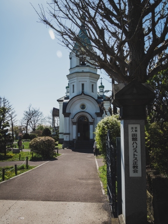
4. Visit the Hakodate Orthodox Church
Location: https://goo.gl/maps/5VvmQot8VvaR9QiP9
Right next to the Catholic church is this circa-19th-century Russian Orthodox church with dramatic night lighting & a bell tower.
5. Go up to Mount Hakodate for Stunning Sunset

Location: https://goo.gl/maps/zEneqoSvFbsXhApJ9
Place that cannot be missed if you visit Hakodate. The views of the city are stunning. Is recommended to go up an hour or even more in advance before the sunset as it is incredibly crowded and barely are free spaces. You can buy tickets from the cable car station
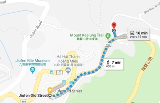
6. Visit Cape Tachimachi for another stunning Sunset


Location: https://goo.gl/maps/zMuLBvUFqFKmfbti6
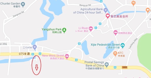
Very unpopular place among tourists and well known among locals, a hidden pearl! The place is quite remote but easily accessible by tram. To do this, get off at Jujigai Station in case your tram has no destination Yachigashira Station
Once you arrive at Yachigashira Station, walk about 15 minutes to here as shown in the image below.
Likewise, if hunger calls you, there is a Lawson next to Yachigashira station!

7. Walk in Goryōkaku Park & Go up to its Tower for 360 Views


Location: https://goo.gl/maps/Xt4qtJqqZ1PhXtph7
100% recommended place to enjoy a beautiful day in the park. The sakura trees here are amazing and cover practically the whole park.
It is also recommended to climb the park tower, as it offers fantastic 360º views of the area
To get here, just take the tram to Goryokaku-Koen-Mae Station and walk to the park. There are indications along the way.
And in case hunger calls again, there is a fantastic restaurant right next to the park called AJISAI. Normally it is always full but the queue is quite fast. Shio Ramen is the typical dish of Hakodate! Must try!

Asahikawa
To get to Asahikawa from Sapporo, it is possible by JR train Lilac-Kamui (express train) at about ¥ 4,810. The journey takes about 2 hours and 15 minutes and the views from the train are amazing.
The final destination is Asahikawa Station, right next to it there is an AEON mall that will be your best friend if you are here for a couple of days.
Right in front of the mall is the busiest and most popular street in the area, full of restaurants, shops, cafes … impossible not to find food here!
This city doesn’t offer many things to visit but it’s a great area to visit Furano & Biei! If you do not have a car, the train is your best transportation and Asahikawa is the best place to stay and move around
1. Relax at Tokiwa Park


Location: https://goo.gl/maps/s7kUsLwrmnRZvD1f6
This spacious, serene park with 2 large ponds, swans & cherry blossoms is a popular place to walk.
2. Walk in Asahikawa Forest Park

Location: https://goo.gl/maps/1PoQyEbRsh4kpccC6
Ideal to spend a morning if you have no more plans to do. The sakura trees are really amazing at this park!
3. Explore Furano & Biei
If something is really worth seeing, it is Furano & Biei and their incredible fields and flowers. Although during the Sakura season the flower fields have not yet blossomed, the views and landscapes are really amazing.
To visit these two places by train, I would recommend visiting Furano first and not missing Tomita Farm. This farm offers beautiful lavender fields that bloom from June.
Furano
Location: https://goo.gl/maps/azbj2VstSSMUX1Va9
To get here, take the train and get off at Lavender-Farm Station or Naka-Furano Station. You can pay directly to the driver or buy tickets at Asahikawa and Furano station.


Biei
Location: https://goo.gl/maps/SmSQGt3J8eAdgFFCA
Once you finish watching Furano, take the train to Biei Station.
In this place there are several places to visit, such as Mild Seven Hills, Zerubu Hills or Hokusei-no-oka Observatory Park. To move around is recommended to rent electric bicycles or motorcycle/car. There is a rental shop right next to the station at this location.
If the night is not coming yet, I would recommend visiting Mild Seven Hills and Zerubu Hills. If you have lack of time as was my case, Mild Seven Hills is the perfect choice.
Along the road on the way to Mild Seven Hills there is a farm where you can taste very popular ice creams!

Mild Seven Hills offers several points with incredible landscapes. Simply walk or move around and enjoy the nature